A pilot's honest take: The Matrice 4E is the mapping workhorse of the Matrice 4 series: a mechanical-shutter wide camera built for photogrammetry, plus telephoto for detail capture, with RTK support for survey-grade accuracy. If your deliverable is an orthomosaic, a 3D model, or construction progress documentation, this is the purpose-built tool. I produce orthomosaic and mapping deliverables for Minnesota clients; this is the aircraft class that work runs on.
Who it's for: Surveyors, engineering and construction firms, aggregate and stockpile measurement, ag operations, and municipalities. Need thermal too? Step up to the Matrice 4T.
Why buy it here: Authorized dealer with full warranty standing and DJI Care Enterprise eligibility, shipped nationwide from authorized inventory. Minnesota buyers can add setup, training, and mapping-workflow consulting from a pilot who actually delivers this kind of work.
Buying for a firm or fleet? Enterprise pricing is moving right now. For multiple units, RTK base stations, payloads, or accessories, request current pricing and availability. See the full lineup on our DJI Enterprise page.
Availability note: New DJI model approvals are currently blocked in the U.S., but previously authorized models like this one remain fully legal to sell, buy, and fly. Authorized inventory is finite. When it's gone, warranty-backed units get scarce.
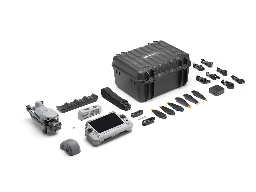
Full specifications & what's in the box:
DJI Matrice 4E: Revolutionizing Mapping and Surveying with Advanced Efficiency
The DJI Matrice 4E is purpose-built for geospatial professionals seeking cutting-edge technology for surveying, mapping, and modeling. As a part of DJI's innovative Matrice 4 Series, this drone delivers exceptional efficiency, precision, and operational simplicity.
With features like 5-directional oblique capture, Distortion Correction 2.0, and an impressive 49-minute flight time, the Matrice 4E is the ultimate tool for professionals who demand accurate, actionable data in even the most challenging environments.
The Matrice 4E pushes the boundaries of what's possible in aerial mapping and modeling. Its intelligent features and advanced imaging tools are part of a broader evolution in enterprise drone technology.
Unmatched Mapping Performance
Extended 49-Minute Flight Time: Stay airborne longer and cover more ground in a single mission. With a maximum flight time of 49 minutes, the Matrice 4E minimizes downtime for battery swaps and maximizes data collection per sortie-ideal for large-area mapping, infrastructure inspection, and time-sensitive missions.
5-Directional Oblique Imaging: Capture five angles in a single pass-nadir plus four oblique directions-boosting mapping efficiency by up to 40%. This feature enhances 3D model quality, improves vertical surface visibility, and delivers more comprehensive datasets with fewer flights.
Rapid-Fire Data Capture (0.5-Second Interval): Collect images every half-second to dramatically speed up fieldwork. This ultra-fast capture rate supports high-resolution, high-volume data collection-essential for tight deadlines and commercial-scale mapping operations.
Precision Engineered for Accuracy
Distortion Correction 2.0 : Ensure millimeter-level accuracy with next-gen distortion correction. Residual distortion is reduced to under two pixels, giving you cleaner data for photogrammetry, topography, and digital twin creation-even at the edges of the image.
Factory-Calibrated Multi-Camera Array: Each wide-angle lens undergoes rigorous factory calibration, ensuring consistent geometric accuracy across the entire image set. Paired with DJI Terra, the system produces superior reconstruction fidelity with minimal post-processing.
Streamlined Workflow and Safer Flight
Smart 3D Capture via RC Plus 2: Create precise flight plans and generate detailed 3D mapping routes directly from the included RC Plus 2 controller-no laptop, no extra software. This onboard intelligence simplifies setup and keeps teams agile in the field.
Omnidirectional Obstacle Avoidance: Fly with confidence in complex environments. The Matrice 4E's advanced obstacle sensing system scans in all directions, providing real-time hazard detection and avoidance for safer missions in urban, industrial, or forested areas.
Applications
Surveying and Mapping
Large-Scale Aerial Surveys: The Matrice 4E's extended flight time, multi-directional capture, and high-speed data collection make it ideal for government departments, surveying firms, and planning organizations.
Topographic Data Collection: Achieve unparalleled accuracy in digital terrain modeling and mapping with distortion correction and DJI Terra integration.
Construction and Planning
Site Development and Modeling: Generate precise, detailed 3D models of construction sites and infrastructure projects, ensuring accurate planning and execution.
Building Modeling: Perfect for architectural heritage conservation, detailed modeling projects, and fire safety planning.
Asset Inspections
Infrastructure Inspections: Conduct thorough evaluations of bridges, buildings, and other structures using high-resolution imaging and flexible zoom options.
Ideal Use Cases for the Matrice 4E
Topographic Mapping: Map large areas quickly with 0.5-second image intervals and high-precision output. Built for surveyors and AEC teams.
Urban 3D Modeling: Capture complete building facades with 5-directional imaging. Ideal for smart city planning and digital twin creation.
Infrastructure Inspection: Safely inspect power lines, pipelines, and bridges with extended flight time and obstacle avoidance.
Environmental Monitoring: Efficiently survey ecosystems, coastlines, and forests. A solid tool for conservation and land management.
Disaster Response: Deploy fast and generate 3D maps on-site. Supports real-time damage analysis and emergency logistics.